【~連載~静岡の歴史を学ぼう261】Anzai area Part1 安西 パート1

※ この記事は「静岡移住計画Facebook」に掲載しております。
静岡浅間神社の西側にある安西。現在は茶商の多い地区です。南北朝の時代(1337– 1392年)から記録に見られる地名です。
Anzai area Part1
安西 パート1
According to a series of historical books titled ‘Sunkoku Zasshi’, the Abe River in the ancient time used to flow along the western foot of Mt. Shizuhata, and the Anzai area was located in the west shore of the Abe River.
歴史書の「駿国雑志」によると、古代の安倍川は賤機山の西麓に沿って流れていて、安西地区は安倍川の西岸にありました。

静岡浅間神社の西側からぐるっと東側にかけて水の流れがあります。
Therefore, the area was called ’Anzai’, which literally refers to "west of the Abe River".
ですからその地区は「安西」と呼ばれ、文字通り「安倍川の西」を指します。

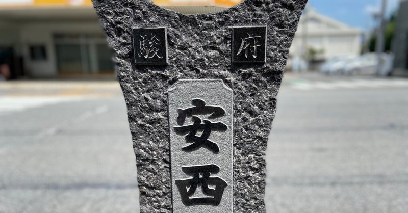
The land name, Anzai, can be read in ancient documents written in March 1337 by Ashikaga Tadayoshi, who was a brother of Ashikaga Takauji, the first Shogun of the Muromachi military government in Kyoto.
地名の安西は1337年(建武四年)3月、足利直義により書かれた古文書に出てきます。足利直義とは、京都に室町幕府を設立した初代将軍である、足利尊氏の弟です。

足利直義ではないか、と言われています。
Moreover, there is another historical document written on December 10, 1348 stating that the third Shogun, Ashikaga Yoshimitsu gave Imagawa Yasunori, Suruga region's local ruler, this land of the Anzai area.
さらに、1348年(貞和四年)12月10日の記録では、三代将軍足利義満が今川泰範に安西郷を与えるという別の記録もあります。

It was written on the historical books titled ‘Suguga Shiryo’ that this place was samurai’s residential area during the Imagawa family’s ruling period.
歴史書の「駿河志料」によると、今川氏が支配した時代にはこの場所は武士の居住地であったと書かれています。
At the beginning of the Edo period, Tokugawa Ieyasu constructed a large-scale river bank called ’Sumpu Okakoi Tsutsumi’.
江戸時代の初期、徳川家康は「駿府御囲堤」と呼ばれる大規模な堤防を築きました。

通称、薩摩土手
With this construction, the current of the Abe River was redirected to a more western part of Sumpu.
この建設により、安倍川の流れはさらに駿府の西側に移動しました。
(参考文献)「徳川家康と駿府城下町」黒澤 脩著 静岡谷島屋

安倍川橋にて(静岡市葵区と駿河区の境目)
この記事が気に入ったらサポートをしてみませんか?