
Application of VR in Education - Why We Do 3D Scanning? Bringing the Latest Technology to the Next Generation

The World Scan Project (WSP) uses drones to scan 3D data, which is then converted into images and utilized in various ways. One such application is "3D DIVER," which is widely used in Japan and abroad as a next-generation educational system. It is a revolutionary tool that allows visitors to view and learn about world heritage sites and historical buildings in VR.

During the spread of COVID-19., school excursions were canceled one after another at junior high and high schools across the country. In response to requests for learning alternatives to school excursions, WSP conducted a special class using VR and drones at Tokyo Metropolitan Oedo High School in 2021. As part of the program, we provided a "3D virtual school trip" to experience Okinawa in VR, where the students were scheduled to go on a school excursion.


In 2023, our CTO Ichikawa visited Mizukaido Daiichi High School to give a lecture on "Digital Archaeology Using Drones. In his 20-minute lecture, Ichikawa, who entered this world as a video creator, introduced how he surveyed archaeological sites around the world, along with the data he filmed. He also reported on a case in which he succeeded in filming a mummy on top of a towering cliff in the Chachapoyas region of southern Amazonas at the request of the Peruvian government, and on a survey of a pyramid conducted with special permission from the Egyptian government. The students from Mizukaido Daiichi High School also reported on the success of the mummy on the cliff.


Drones, the latest technology, are also used in pyramid measurement.
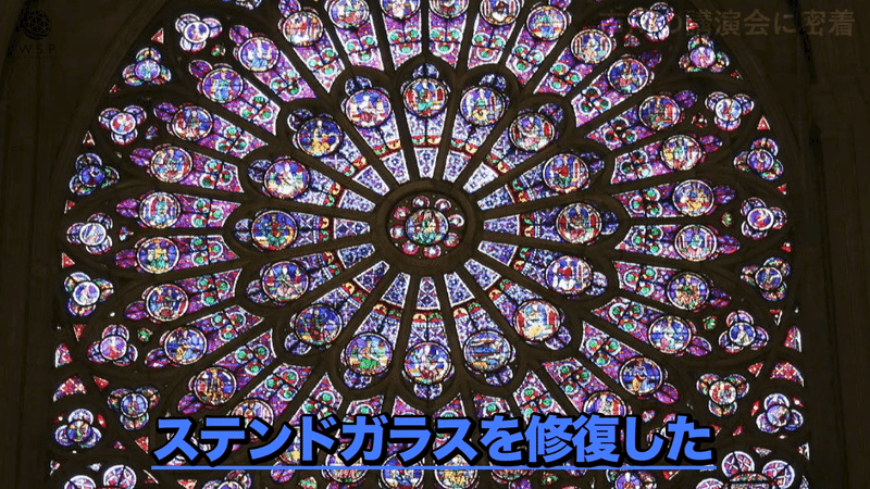
Photogrammetry is the process of combining multiple pieces of data taken by a drone and converting them into 3D. The data can be used to determine the length and other details of buildings, making it possible to generate elaborate drawings. Photogrammetry is also helping to restore a replica of the Arc de Triomphe at the ancient Palmyra site (Syria), which was destroyed in a war, and the Notre-Dame Cathedral (France), which was destroyed by fire and is scheduled for completion by 2024.
Photogrammetry is also an effective method for restoring delicate designs such as detailed carvings and specially colored tiles in Shuri Castle (Shurijo), which was destroyed by fire in 2019 and is currently undergoing restoration work.


After the lecture, the students put on goggles to experience the images and asked questions.
Q: Male student, "Is there anything you pay attention to when making images, or is there a place that was rejected or something?"
A: Ichikawa: "It is important not to get them drunk and not to bore them. There is a lot of data that was rejected. We are not just taking pictures, but we are also taking pictures of small foreign objects. We have a lot of data, but we edit it into a composition that will not bore you.
Q: Female student: "What do you find interesting and what do you find difficult?"
A: Ichikawa: "When you use a drone, you can see places that you would not normally see. For example, you can easily see the rooftop of this building or the roof of your own house when you use a drone. The only thing I don't like is that I often drop the drone when I am flying it. I do it thinking it's already going to fall off."

Please watch the video of the lecture here.
The appeal of photogrammetry is that it makes it possible to visualize 3D scan data in such a way that heritage sites around the world can be easily viewed in museums or even at home. The Worldscan Project, which continues to use drones to photogrammetricize historical sites and heritage in Japan and abroad, will continue to preserve valuable data for future generations and communicate the importance of preserving our heritage.
For more information on WSP's photogrammetry technology, please click the videos below.
If you are interested in this activity, please follow and support the WSP.
この記事が気に入ったらサポートをしてみませんか?