Day 662 [Ukraine War Map] New Ukraine counterattack in Spring! Russia inflation like a broken car

Ukraine war situation update daily
0:00 Introduction
0:54 General Matters on the Situation in Ukraine
2:00 News on the situation in Ukraine and Russia
2:09 Russian Central Bank Governor's Press Conference: "Russia's Economy is a Broken Car"
3:52 "Ukrainian Army Plans Spring Offensive," German Newspaper Says
5:00 War situation in various regions
5:07 Northeastern Luhansk Oblast, in the direction of Shinkivka and Serebryansky forests
5:45 Eastern Bohdanivka, Krishtivka and Andrivka in the direction of Bakhmut
6:56 Southeastern Donetsk Oblast, in the direction of Audyiuka and Marinka
11:26 War situation in the south Zaporizha Oblast Belbove, Lobochine, Novoprokopivka
12:52 Explosion and fire incident in the rear area
13:08 War situation in the south, Kulinky, Poima, Pishtchanivka, Herson Oblast
13:50 Russian tank engines are protected by explosion reaction armor
#ukraine
#Russianarmy
#PresidentPutin
➡The latest Update of Ukrainian war situation explained clearly with maps! Video of the day's report on the day of the event.
➡We summarize in Japanese and provide subtitles in English and Ukrainian, focusing on reports from the General Staff of the Ukrainian Armed Forces, the latest ISW, the latest defense studies, the latest defense-related websites, Twitter, and Telegram.
➡For past videos, go to the playlist
https://youtube.com/playlist?list=PLYeggD4iKOM_yLyhL2ItsSy0dHDKaEKmW
➡The latest war situation is available alternately in Japanese and English every day:
https://www.youtube.com/@Invest_and_Living/
➡For more comfortable viewing
The release time varies from day to day. Subscribe to the channel and turn on notification.
Red: Russian side Blue: Ukrainian side Orange: disputed
There are squares of 10 km on each side in some places.
Size of the field: about 1kmX1.6km
Distance
Svatove-Kremina 45km/Kremina-Bakhmut 55km/Bakhmut-Donetsk 65km/Donetsk-Mariupol 100km/Mariupol-Mertopol 170km/Mertopol-Khrson 200km
What were the losses of the Ukranian military?
Data not disclosed and unknown
➡Materials
OST of WoWP, WoT, WoWs - Wargaming.net
Use is subject to confirmation in accordance with the terms of use.
Hello everyone.
Today I will continue to bring you the latest Ukrainian situation in a compact and
easy to understand
format with the use of maps.
I'd like to welcome you all to our video.
If you subscribe to our channel and
turn on notifications,
you will be notified when new videos are released.
You can also view past videos from the playlist.
Situation in Ukraine
It's been 662 days since Russia invaded Kyiv,
so let's start with general matters.
According to the General Staff of the Ukrainian Armed Forces,
the losses of Russian troops are,
1250 soldiers
19 tanks
25 armored fighting vehicles
37 guns
3 multiple rocket launchers
4 air defense systems
40 drones
1 cruise missile
60 other vehicles.
Across the entire front,
96 ground battles were reported in a single day.
and
the ratio of the number of losses of Ukrainian equipment to Russian losses,
which can be visually confirmed,
is 1 to 1.1 compared to the number of losses of Ukrainian equipment.
Russian losses are mostly infantry fighting vehicles and
tanks,
confirming that
they are trying to attack in convoys.
Conversely,
losses on the Ukrainian side are mostly SUVs and
boats.
Here is a brief news report on the situation in Ukraine.
You can also use YouTube's chapter feature to watch where necessary.
1st.
The Russian Central Bank raised its policy rate to 16% on March 15,
but the "pessimistic comments" of the Central Bank Governor are causing a stir.
The Governor of the Central Bank of Russia,
Vladimir Nabiullina,
compared the current state of the Russian economy to that
of a car,
If you try to go too fast,
sooner or later the engine will overheat and
you won't be able to go very far.
We may be rushing ahead,
but it won't last long.
I guess he was referring to a "car with a coolant leak,
In Russia,
the original workers have been sent off to war,
and
with unemployment as low as 3%,
there is a continuing shortage of workers,
The production is heavily weighted toward military supplies,
and
inflation is accelerating due to the shortage of
goods necessary for the people's daily lives.
The President is concerned that
"if wage growth does not keep pace with prices,
savings will be eaten away and
the well-being of society will not be achieved.
Russian economic experts assessed the situation as "a postponement of
the problems ahead of President Putin's reelection."
The Economist noted that
Russia needs to raise interest rates more to curb production,
but that
inflation will accelerate further as long as President Putin puts money into
increasing weapons production,
We are warmly watching the Russian economy to see where it goes.
The contributor also selfishly has a feeling that
we will see the Russian economy crumble noisily in the second half of next year.
Second.
According to the German newspaper Veld.
noted that
Ukraine will carry out a major offensive operation next year after receiving Western air power.
Ukrainian commander Sardzhny noted that
the "premature cancellation" of the summer "reversal offensive" had allowed him to
"preserve 95% of the weapons" supplied by the West,
which would be "used in next year's operations along with air power.
Similarly,
Bild published an article titled "Ukraine's New War Plan,
" reporting that
Ukraine had switched to a "withdrawal operation" that
would inflict maximum losses on Russian forces,
retreating slightly during the winter months until military assistance from the West arrives.
The article noted that
a "bridgehead on the left bank of the Dnipro River could become a base for a counterattack,
" and
that
a 60-kilometer advance from the bridgehead to Crimea could lead to "an early end to the war."
Now,
here is the war situation in each region.
I will tell you where the war situation is changing.
Northeast: Luhansk region
Eastern part,
toward Bakhmut
We will report on the war situation in the area from Kupyansk to Svatove-Kreminna line and
from Sibersk to the area around Bakhmut.
In this sector,
the Russians attacked 11 times in Shinkivka,
5 times in and
around the Serebryanskiy Forest,
and
18 times in the direction of Bakhmut.
Northeast: from Kupyansk to Sibersk
There was no information affecting the war situation in this area.
Eastern Bakhmut
In this area,
Russian forces are advancing on the offensive,
while Ukrainian forces are retreating and
cutting Russian forces' strength.
1st.
At the racecourse west of Kromove,
according to the located video,
Russian troops have crossed the O0506 line and
reached the battle map.
The one we are showing is of the 3rd Assault Brigade of the Ukrainian Army,
which is playing tag with the Russian soldiers at the location of the war map.
Due to various rules and
regulations,
we cannot show you the moment they are captured,
but what follows is exactly what you would expect.
The 3rd Assault Brigade is originally a unit located south of Bakhmut,
but it seems that
they were called to this side as well.
We have updated the battle map to assume that
the Russians have occupied the area in front of the racetrack.
The area is very small.
There was no other information affecting the war situation map in this area.
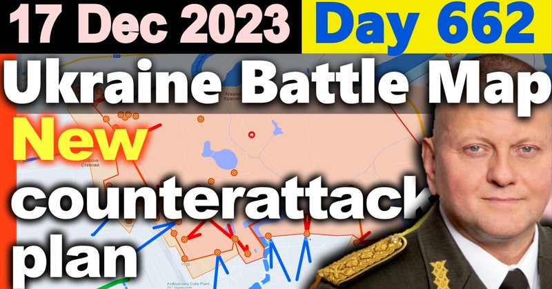
Southeast Donetsk Oblast
Weather in Avdiivka is cloudy with occasional light snow.
The minimum temperature is -8 degrees Celsius,
the maximum -2 degrees Celsius.
Today's weather forecast is cloudy with light snow
The following is an update on the situation in the areas of Avdiivka,
Marinka,
and
Vuhledar.
Avdiivka area
According to satellite imagery analyzed and
counted by Frontier Intelligence Insight,
the Russian military reported the loss of 211 armored vehicles from the beginning of
the offensive in Avdiivka until November 28,
with more than 100 of these vehicles lost in the first three weeks of the offensive.
On the other hand,
the Ukrainian military stated that
they lost only 7 vehicles.
The calculated kill ratio is 30 to 1.
Now,
the Russians made 34 attacks in this direction and
made an assault on the siege of Avdiivka.
1st.
In Krasnohorivka,
Ukrainian Su-25s bombed the Russian command
center three houses east of the government building in the center of the city,
cutting off Russian forces before they could reach the front line.
2nd.
Heavy fighting is taking place in Stepove.
The positional video shows that
Russian BMP2 infantry fighting vehicles and
MTLB armored transports have been repulsed at the location shown on the battle map,
and
that
Russian troops are advancing slightly.
The one shown is of the Ukrainian army,
where a Russian vehicle rushed toward Stepove and
was destroyed by a mine.
Considering other information,
we have updated the battle map to show the area in front of this location as
occupied by Russian forces from the disputed area.
You can follow the changes in the war situation in full screen mode at high resolution.
Other than that,
no information affecting the battle map was available for the factories south of Telikon and
south of Avdiivka,
and
the Vozhane to Pervomaiske axis of attack,
where the Ukrainian army repulsed the Russian attack.
Marinka sector
The Russians launched 13 attacks on the northern part of Marinka and
Novomihailivka.
1st.
In Marinka,
Ukrainian troops appear to have laid a minefield west of the town,
blocking the Russian advance.
The Russians bombed and
then attacked west of Marinka,
but the Ukrainians defended themselves,
with no result for the Russians.
Second.
Unconfirmed reports indicate that
in Novomihailivka the Russians advanced from the south and
captured the cemetery south of the town.
The war situation map has been updated with the area around the cemetery as disputed territory,
assuming that
the Russians have occupied up to the southern defense line of the town,
based on a synthesis of several pieces of information.
Drawing from the map,
we can explain that
the Russians would like to occupy the O0532 line between Novomihailivka and
Vuhledar to reduce the burden of troop movement and
supply lines,
but Novomihailivka itself is of little strategic value to the Ukrainian military,
and
the town is easily defended by a continuous line of towns to the west.
Since it is easy to defend,
the Ukrainian army may defend itself by gradually retreating while
inflicting damage on the Russian army.
Vuhledar area
In Mykilske,
Vuhledar,
and
Pavlivka,
the Russians attacked the Ukrainian positions using incendiary bombs,
multiple rocket launchers,
and
other weapons for surface control on a large scale in the locations indicated on the battle map.
The map shows the situation in the area north of Mykilinske.
No other information was found that
would affect the battle map in this area.
South,
Zaporizhia Province.
In this sector,
the Russians attacked twice at Stalomaiorsk and
eight times at Robotyne.
1st.
North of Verbove,
we have received information from the Russian side confirming
what we reported as unconfirmed information on December 14.
We are showing you a part of the area where Russian troops were
patrolling in the vicinity of the battle map,
Ukrainian troops suddenly attacked,
and
the Russians responded by taking cover.
We have updated the war map to show part of the disputed area in
this vicinity as Russian-occupied territory.
The area is about 3 square kilometers.
2nd.
West of Robotyne,
according to the positional video,
Ukrainian troops repelled Russian BMP3 infantry fighting vehicles at the location on the battle map,
confirming the presence of Russian troops.
The image shown is from the 65th Mechanized Brigade of the Ukrainian Armed Forces and
was observed from a drone at the location on the battle map.
This location was changed to disputed territory in an unconfirmed report on December 13,
but we have updated the war map to show part of it as Russian-occupied territory.
The area will be about 5 square kilometers.
Rear Area
Today there are reports of an explosion in Sevastopol,
an explosion caused by a drone strike in Taganrog,
and
an explosion and
blaze at an oil facility in Donetsk.
South,
province of Kherson.
According to the located video,
Russian forces conducted airstrikes on the location on the battle map,
and
unconfirmed reports indicate that
Russian paratroopers then attacked from two directions,
south and
west,
in heavy fighting at a location recaptured by Ukrainian forces on the 12th.
What we are showing you is a view of the Russian air strikes,
The shape of the ground battle may be that
the Ukrainian army,
which was attacked in its rear base by air strikes,
is being pushed back because it cannot provide support,
and
we have updated the battle map of this area from
the Ukrainian army's recaptured area to the disputed area.
Other.
Forbes published an article claiming that
"Russia has developed a new suicide tank.
The tanks are fitted with explosion-reactive armor just above
the engine in case the enemy attacks.
However,
as our viewers know,
tanks are generally thinly armored in the engine compartment and
have holes for exhaust and
exhaust heat,
so installing explosive reactive armor in this location would be tantamount to suicide,
as it would surely destroy the engine if it were to operate in any way,
even if it is not a hit bullet. This is suicide.
This suicide tank is located in Krynky,
and
Forbes,
citing the record of Russian military defeats in this area,
noted that
it "speaks volumes about the degree of experience and
knowledge of the Russian soldiers."
That's all for today.
Thank you for watching.
この記事が気に入ったらサポートをしてみませんか?