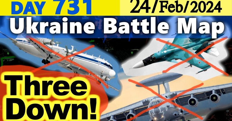
Day 731 [Ukraine War Map] $350m Aircraft Loss on Russia! A-50U, SU-34 and one IL-22M, it is said.

[February 24, Ukraine Situation Overview]
0:00 Introduction
0:35 General matters on the situation in Ukraine
1:35 Latest news on the situation in Russia and Ukraine
1:45 Two Ukrainian aircraft shot down, one of them a state-of-the-art early-warning aircraft
3:20 New Threat to Ukraine: Russia to Apply for Annexation of Russian Primorskiy Territory
4:27 "Russia will be exhausted this year" Ukrainian military hints at timing of counterattack
4:16 War situation in various regions
4:25 War situation in northeastern Luhansk, eastern Bakhmut
8:37 Southeast, Donetsk Oblast, Avdiivka, Marinka
11:46 South, Zaporizhia Oblast, Verbovye, Robotyne
12:22 South, Khrson Oblast, Krynky - war situation
#Battle situation in #Ukraine
#Russian army
#President Putin.
The latest Ukrainian war situation that the media never tells you about, explained clearly with maps! The war situation is updated twice a day.
This video is summarized in Japanese with reports from the General Staff of the Ukrainian Armed Forces, the latest ISW, the latest defense studies, the latest defense-related websites, Twitter, and Telegram.
●For past videos, go to the playlist.
https://www.youtube.com/playlist?list=PLYeggD4iKOM_yLyhL2ItsSy0dHDKaEKmW
■For more comfortable viewing
Release time varies from day to day. Subscribe to the channel and turn on notification.
Red: Russian side Blue: Ukrainian side Orange: disputed
There are squares of 10 km on each side in some places.
Size of the field: about 1kmX1.6km
Distance
Svatovo-Kremina 45km/Kremina-Bakhmut 55km/Bakhmut-Donetsk 65km/Donetsk-Mariupol 100km/Mariupol-Mertopoli 170km/Mertopol-Herson 200km
● What were the losses of the Ukranian military?
Data not disclosed and unknown
●Contents are posted in Japanese, English, and Ukrainian in NOTE
https://note.com/sumaitotoushi/
Materials
OST of WoWP, WoT, WoWs - Wargaming.net
Use is subject to confirmation in accordance with terms and conditions.
Hello everyone.
Today I will continue to bring you the latest Ukrainian situation in a compact and easy to understand format with the use of maps.
I'd like to welcome you all to our video.
If you subscribe to our channel and turn on notifications,
you will be notified when new videos are released.
You can also view past videos from the playlist.
Situation in Ukraine
It has been 2 years and 1 day since Russia invaded Kyiv,
731 days.
First,
a general matter.
According to the General Staff of the Ukrainian Armed Forces,
the Russian losses were 770 soldiers
8 tanks
15 armored combat vehicles
36 artillery pieces
2 air defense systems
1 aircraft
31 drones
2 cruise missiles
29 other vehicles.
In total,
101 ground battles were reported on the entire front during the day.
And the ratio of the number of Ukrainian equipment losses to Russian losses,
which can be visually confirmed,
is 1 to 1.1 compared to the losses of the Ukrainian side.
The Russian side has lost more infantry fighting vehicles,
while the Ukrainian side has also suffered significant losses of infantry fighting vehicles and pickup trucks.
This is a short news report about the situation in Ukraine.
You can also use YouTube's chapter feature to watch where you want.
1.
The Ukrainian military has again shot down two Russian planes.
One of them,
a Su34,
was shot down in the Kherson province.
In the video you can see heavy flames rising from the ground.
The other,
an upgraded A50U early warning aircraft,
was shot down in Krasnodar.
The video shows a radar decoy being fired,
one of the missiles chasing the decoy,
another hitting the plane,
and then the plane crashing with an orange flash.
In addition,
the ground at the presumed crash site is heavily burned.
The A50 is an expensive aircraft,
costing $35 billion (49 billion yen) each,
and the fact that it was shot down means that in addition to the loss of the aircraft,
the five pilots and 10 to 11 radar operators on board were also sent to hell.
This means that the Ukrainian military has now shot down two of the eight Russian-owned A50s.
And as viewers may have noticed,
the problem here is the method of downing,
as Karai in Krasnodar Oblast,
where the plane was shot down,
is 170 kilometers from the front line and considered out of range even at Patriot range.
There seems to be an unknown method.
2.
The Primorsky Dniester region,
located on the border between Ukraine and Moldova,
will hold its Supreme Council meeting on the 28th of this month to request annexation by Russia.
The Dniester region is located in Moldova and is not under government control. 3,000 Russian troops are stationed there under the guise of maintaining security.
It is said to be of no economic use to Russia,
and since it is surrounded only by Moldova and Ukraine,
it is unlikely to become a Russian military base,
but it can be used as a base for militia groups like those in Donetsk and the Luhansk People's Republic,
and President Putin may accept this. It is not at all clear that he will,
and if he does accept it and it is incorporated into Russia,
it will pose an unpredictable threat not only to Moldova but also to Ukraine.
Now,
here is the war situation in each region.
I will tell you where the war situation is changing.
Northeast: Luhansk region
Eastern part,
towards Bakhmut
We will report about the war situation on the Svatove-Kreminna line from Halkiu and Kupyansk,
and from the area around Siversk to Bakhmut.
In this area the Russians attacked 5 times in Shinkivka and Tabayivka,
14 times in Terny and its surroundings,
and 16 times in the direction of Bakhmut.
Svatove-Kreminna line
1.
East of Terny,
positional video shows Ukrainian troops destroying a Russian T72 with an anti-tank missile,
confirming that this location is at least disputed.
What we are showing you is from the Ukrainian side,
and the location is shown on the map.
We have updated the battle map to show this location as disputed,
although we had assumed that the Russians had occupied this area on February 5th.
2.
Also east of Yampolivka,
positional video shows Ukrainian troops counterattacking and advancing.
At the location shown on the map,
an operator of an M113 of the 63rd Mechanized Brigade of the Ukrainian Army approaches a trench and rescues a fellow soldier amid a barrage of artillery fire.
This location,
like the first,
was also mapped as a Russian advance on February 5th,
but we have updated the battle map to show it as disputed territory.
Around Sibersk
1.
In Bilohorivka,
the Russians attacked the town from the north of the sewage plant with a large convoy of vehicles,
but were repulsed by the Ukrainian army.
The Russian BMP infantry fighting vehicles were destroyed in the attack,
and the Russians lost seven BMPs in the attack.
The battle map remains unchanged,
as the attack took place in disputed territory.
2.
Meanwhile,
the Russians launched an attack along the railroad tracks east of Veseret.
Russian paratroopers in armored vehicles advanced to the side of the Ukrainian trenches and engaged the Ukrainian troops in a battle of positions,
from which the Ukrainian troops withdrew.
What we are showing you is a view of the location shown on the map.
This is the location that we reported as the Russian advance on February 16,
and we have updated the battle map again to include the disputed area.
Direction Bakhmut
1.
East of the town of Ivanivske,
where we reported yesterday that Russian troops were advancing and urban warfare was beginning,
Russian troops attacked day after day,
but were repelled by Ukrainian troops after two BMP2 infantry fighting vehicles and a BTR80 armored fighting vehicle were destroyed at the entrance to the town.
The Russians also attacked the southern axis of the attack with three BMP3 infantry fighting vehicles,
which were also repulsed by Ukrainian drones.
This is a view of the location shown on the map,
as seen from the drone of the 93rd Mechanized Brigade Signum Battalion of the Ukrainian Army.
There are no changes to the battle map.
2.
East of the pond in Klishchiivka,
Russian forces launched an attack,
but were repulsed when they stepped on a mine.
Ukrainian forces likely retreated east of the pond,
and part of the battle map was updated from Ukrainian recaptured to disputed territory.
Otherwise,
the Russian attack was repulsed by Ukrainian forces,
and no other information affecting the battle map was available.
Southeast Donetsk region
The weather in Avdiivka: cloudy,
sometimes sunny.
The minimum temperature is -2 degrees Celsius and the maximum is 4 degrees Celsius.
Today's weather forecast is cloudy with occasional showers.
Below is an update on the situation in the areas of Avdiivka,
Marinka and Vuhledar.
Avdiivka
The Russians carried out 10 attacks in this area.
1.
In Stepove the Russians advanced and captured half of the settlement.
According to the position video,
the presence of Russian troops in this place can be confirmed,
as Ukrainian troops are shelling the settlement from M1A1 Abrams tank guns.
The Russian troops can be seen attacking the mapped Russian position in Stepove from the outskirts of Berdych,
1.5 kilometers away.
The 47th Mechanized Brigade of the Ukrainian Army is shown at the location shown on the map.
An Abrams tank is attacking,
and the tactic appears to be the same as using tanks from the former Soviet Union.
The battle map has been updated to show half of the settlement of Stepove as occupied by the Russians.
2.
East of Orlivka,
where we reported in yesterday's video that Russian troops may have advanced,
we have updated the battle map from the Ukrainian artillery target as Russian troops advanced about a field's distance from the coal plant.
3.
In Severne,
where we reported yesterday that Russian troops may have advanced,
multiple sources indicate that Russian troops have also advanced and are engaged in a ground battle over the eastern part of the settlement.
We have updated the battle map of the area from contested to Russian-occupied.
The area is approximately 7 square kilometers.
The topography of the area is described as follows: from the highlands of Avdiivka,
the altitude decreases as one moves westward,
and a river flows along the topography.
The Ukrainian army will defend itself with settlements along the river,
and eventually the river shown on the map may become a defensive line,
but the front may stabilize without going that far.
In the other attack axes,
Pervomaiske and Neveleske,
the Russian attack will be repelled by the Ukrainian army,
and the battle map will remain unchanged.
Marinka Sector
In this sector the Russians attacked Pobieda and Novomichailivka 43 times,
but the Ukrainian army showed remarkable defensive capabilities and repulsed them,
leaving the battle map unchanged.
Southern Zaporizhia Province
In this sector the Russians attacked three times in Zolotaniva and five times in Verbove and Robotyne.
In Robotyne,
as we reported in yesterday's video,
the Ukrainian forces counterattacked,
but according to the video with location information,
they managed to retake the area around the town.
We have updated the battle map from the position of the Russian drone attack,
as the Ukrainian army has advanced south of the town: BBBB
South,
Kherson province.
In this direction,
Russian forces have attacked Krinky five times,
but Ukrainian forces have repulsed them,
leaving no change in the battle map.
On the other hand,
Russian Defense Minister Shoigu has officially announced that the Russian military has "taken full control of Krinky" and told President Putin that with the presidential election coming up,
there could be a problem of responsibility among the Russian military if they had not actually taken the city.
That's all for today.
Thank you for watching.
この記事が気に入ったらサポートをしてみませんか?