NASAとCNESの共同開発による水追跡衛星が、初めて素晴らしい景色を見せた。

NASAのカリフォルニア州パサディナにあるJPL研究所(Jet Propulsion Laboratory in Pasadena, Calif.)が公開している「NASA's Jet Propulsion Laboratory Day in Review」は2023年03月24日に、地表水・海洋トポグラフィミッション(Surface Water and Ocean Topography mission)は、最先端の観測機器がとらえる地球表層水の詳細な姿を初めて見ることができるようにした。
NASAとフランスの宇宙機関CNES(Centre National d'Etudes Spatiales)が主導する国際ミッション「SWOT (Surface Water and Ocean Topography)」は、地球表面の水を初めてとらえ、メキシコ湾流などの海流をかつてないほど詳細に映し出すことができたと発表しました。
SWOTはまた、湖や川などの淡水域を幅100mまで撮影している。
この衛星は、地球表面のほぼすべての水の海抜を測定し、地球表面の水に関する最も包括的な調査のひとつを提供する。SWOTによる淡水域と海洋の観測は、海洋が気候変動や水循環にどのような影響を与えるか、温暖化が湖や川、貯水池の貯水にどのような影響を与えるか、地域社会が水資源の管理を強化し、洪水やその他の災害に備えるにはどうすればよいか、などの知見を提供することになると言われている。
NASAのビル・ネルソン長官(NASA Administrator Bill Nelson)は、「SWOTの高度な画像は、研究者に力を与え、世界中の淡水と海面上昇の影響を管理する方法を前進させるだろう。」と述べた。「水は地球上で最も重要な資源の一つであり、気候変動の影響に対して脆弱であることが証明されている。SWOTは、地域社会が温暖化の影響に備えるために利用できる重要な情報を提供する。
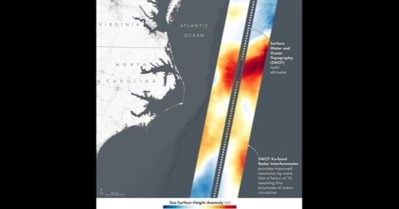
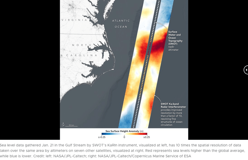
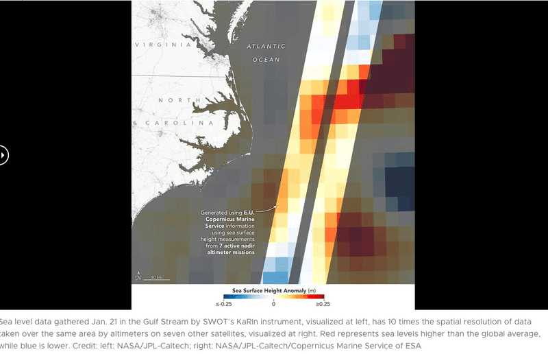
2023年01月21日、SWOTはノースカロライナ(North Carolina)州とバージニア(Virginia)州の沖合にあるメキシコ湾流(Gulf Stream off the coast )の一部で海面を測定しました。SWOTのKaRIn(Ka-band Radar Interferometer/Ka帯レーダー干渉計)の2つのアンテナから取得したデータは、合計75マイル(120km)にわたる幅の広い色付きの帯としてマッピングされた。画像の赤とオレンジの部分は、世界平均より高い海面レベルを、青の部分は、平均より低い海面レベルを表している。
つまり、フランク・シェッツィング(Frank Schaetzing)のSF小説「深海のYrr(Der SCHWARM)」で登場するように、丸い球や風船のようであると考えられてきた海の表面は、ジャガイモのように凸凹であると言われてきたが、それがデータとして証明されることになった。
比較のために、この新しいデータは、高度計と呼ばれる宇宙ベースの機器によって撮影された海面高度のデータと一緒に表示されている。海面高度の測定に広く使われているこの機器は、レーダー信号を地表から跳ね返して測定値を収集する。しかし、従来の高度計は、地球の真下の狭い範囲しか見ることができない。
SWOTの海洋観測の空間分解能は、Sentinel-6 Michael Freilich, Jason-3, Sentinel-3A and 3B, Cryosat-2, Altika, Hai Yang 2Bの7つの衛星が同じ地域に集めた海面高度データの合成画像の10倍である。
合成画像は、ESA(European Space Agency欧州宇宙機関)のCopernicus Marine Serviceの情報を用いて作成したもので、SWOTデータと同じ日の様子を示している。
また、KaRInはロングアイランドの水場の標高を測定し、風景の中にある明るいピンクの斑点で示した。
紫、黄、緑、青の色調は、それぞれ異なる土地の標高を表している。

CNES会長兼CEOのフィリップ・バプティステ'Philippe Baptiste)は、「衛星データによって地球規模で淡水資源を測定する能力は、気候変動に適応しようとする私たちにとって最も重要なものです。」と述べている。「この点で、SWOTの最初の見解は、これまで以上に鮮明な画像を提供してくれます。これらのデータは、水文学、海洋学、沿岸研究の分野における国際的な科学コミュニティにとって、非常に価値のあるものであることが証明されると話している。
この最初の内陸部の画像は、SWOTが衛星がこれまでできなかった方法で、より小さな湖、池、川の詳細を測定できることを示す、心躍るものです。このようなデータは、研究者、政策立案者、水資源管理者にとって有益な方法で、地球表面の淡水の驚異的な記録を作成するために使用される。
「南カリフォルニアにあるNASAのジェット推進研究所のSWOTプロジェクトマネージャーであるパラグ・ヴェイズ(Parag Vaze, SWOT project manager at NASA’s Jet Propulsion Laboratory in Southern California)は、「KaRInは何年もかけて開発・製造され、世界中の水域に関する情報を収集します。」と話している。
NASAも宇宙だけではなく、宇宙から地球をより詳細に知ることが重要と気がついた。
私はこれを数10年前から訴えてきた。
誠意じつまでは、地球より詳しい火星のデータを取得してきた。
それは、人間が地球に住めなくなることが明らかになってからでも十分可能である。
More About the Mission
Launched on Dec. 16, 2022, from Vandenberg Space Force Base in central California, SWOT is now in a period of commissioning, calibration, and validation. Engineers are checking out the performance of the satellite’s systems and science instruments before the planned start of science operations in summer 2023.
The data for these first images was collected by SWOT’s KaRIn instrument, the scientific heart of the satellite. KaRIn has one antenna at each end of a boom that’s 33 feet (10 meters) long. This enables the instrument to look off to either side of a center line directly below the satellite as it bounces microwave signals off Earth’s surface. The returning radar signals arrive at each antenna slightly out of sync, or phase, from one another. When these signals are combined with other information about the antennas and the satellite’s altitude, scientists will be able to map the height of water on Earth’s surface with never-before-seen clarity. KaRIn encountered an issue earlier this year with one of its subsystems; engineers have now resolved the situation, and the instrument is up and running.
SWOT was jointly developed by NASA and CNES, with contributions from the Canadian Space Agency (CSA) and the UK Space Agency. JPL, which is managed for NASA by Caltech in Pasadena, California, leads the U.S. component of the project. For the flight system payload, NASA provided the KaRIn instrument, a GPS science receiver, a laser retroreflector, a two-beam microwave radiometer, and NASA instrument operations. CNES provided the Doppler Orbitography and Radioposition Integrated by Satellite (DORIS) system, the dual frequency Poseidon altimeter (developed by Thales Alenia Space), the KaRIn radio-frequency subsystem (together with Thales Alenia Space and with support from the UK Space Agency), the satellite platform, and ground operations. CSA provided the KaRIn high-power transmitter assembly. NASA provided the launch vehicle and the agency’s Launch Services Program, based at Kennedy Space Center, managed the associated launch services.
To learn more about SWOT, visit:
https://swot.jpl.nasa.gov/
Watch the Latest Water Satellite Unfold Itself in Space
Latest International Water Satellite Packs an Engineering Punch
5 Things to Know About How SWOT Will Look at the World's Water
https://www.jpl.nasa.gov/news/joint-nasa-cnes-water-tracking-satellite-reveals-first-stunning-views?utm_source=iContact&utm_medium=email&utm_campaign=nasajpl&utm_content=daily20230324-1
https://www.jpl.nasa.gov/news/latest-international-water-satellite-packs-an-engineering-punch
https://sealevel.jpl.nasa.gov/missions/technology/
https://www.jpl.nasa.gov/news/nasa-turns-to-the-cloud-for-help-with-next-generation-earth-missions
https://www.jpl.nasa.gov/news/nasa-launches-international-mission-to-survey-earths-water
https://blogs.nasa.gov/swot/2023/02/23/engineers-check-swot-science-instrument-during-commissioning-activities/
https://blogs.nasa.gov/swot/2023/03/17/swot-science-instrument-is-up-and-running-continues-with-commissioning/
https://www.jpl.nasa.gov
この記事が気に入ったらサポートをしてみませんか?